Winds that blow consistently from East to West, around the earth, and near the equator are called Trade Winds. In the early days of trade with the Americas, the merchants used to take advantage of these Trade winds to navigate their ships and make their journeys more enjoyable.
Typically, when the wind blows over the ocean, it pushes the water away from its surface. To fill that gap, the cold water comes up to the surface from deep down, which is usually rich in nutrients suitable for plants and other sea animals. This deep, cold water rising toward the ocean's surface is called upwelling. Therefore, wherever upwelling exists, those locations are suitable for fishing.
The opposite of upwelling is called downwelling. Downwelling happens when the wind causes surface water to build up along a coastline, and the surface water eventually sinks toward the bottom of the ocean.
ENSO
ENSO: El Niño and Southern Oscillation.
EL Niño: Periodic fluctuation in sea surface temperatures.
Southern Oscillation: Air pressure of the overlying atmosphere across the equatorial Pacific Ocean.
Neutral: The middle stage of ENSO.
Though ENSO is a single climate phenomenon, it has three stages. The two opposite phases, “El Niño” and “La Niña”. Neutral is the middle of the continuum.
El Niño

El Niño is a climate pattern that originates in the Pacific Ocean, and it can significantly impact the weather worldwide. When the conditions are normal in the Pacific Ocean, the trade winds blow from east to west along the equator, carrying warm water from South America toward Asia.
When El Niño occurs, trade winds weaken, and warm water gets pushed back East toward the West Coast of the Americas. During El Niño, the upwelling usually occurs on the Pacific Coast of South America and is reversed to downwelling.

In the Central and Eastern tropical Pacific oceans, when the Ocean’s surface warms or gets to above-average temperatures, rainfall reduces in Indonesia and increases over tropical Pacific oceans. Easterly winds are the low-surface winds that usually blow from East to West along the equator, instead weaken, or, in some cases, start blowing in the other direction (West to East).
Etymology of El Niño and La Niña
Around Christmas, the South American fishermen noticed that the coastal waters would warm up often. They named El Niño (Niño being a boy child in Spanish in connection with the religious holiday).
In the late 1960s, Jacob Bjerknes and the team realized that the Ocean and atmosphere changes are interconnected, and the hybrid term “ENSO” was born. But it wasn’t until the late 1980s that the word La Niña or Neutral gained prominence.
Do you know?
Sir Gilbert Walker discovered the “Southern Oscillation,” or the large-scale changes in the sea level pressure across Indonesia and the tropical Pacific, before Jacob Bjerknes.
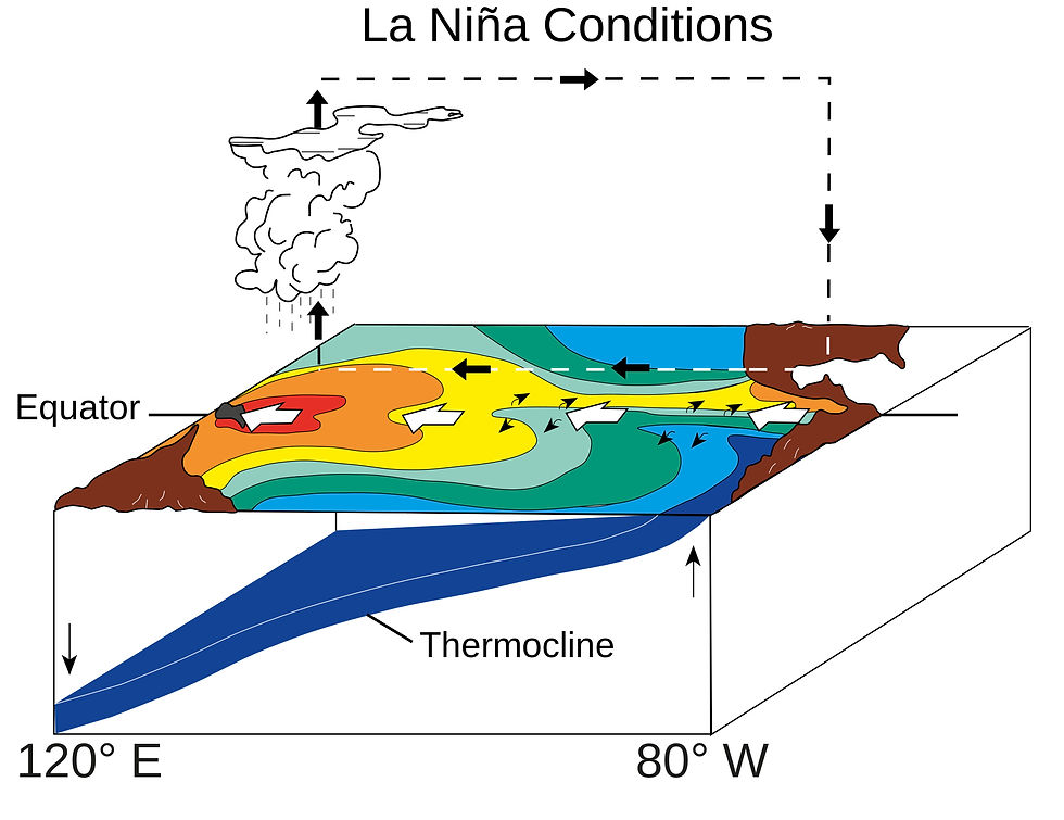
La Niña

La Niña is also a climate pattern originating in the Pacific Ocean, and it can significantly impact the weather worldwide. La Niña is quite opposite to El Niño. During La Niña, the trade winds are more robust than usual, and warmer water gets pushed toward Asia. On the West Coast of the Americas, upwelling increases, bringing the cold, nutrient-rich water to the surface. Marine ecosystems such as fish kingdoms, sea plants, and other dependents benefit from the nutrient-rich water with the increased upwelling from the depths during La Niña.

In the Central and Eastern tropical Pacific Oceans, when the ocean surface drops below-average sea surface temperatures, rainfall reduces over the tropical pacific oceans and increases in Indonesia. The low-surface easterly winds that blow from East to West gets even stronger during this stage.
Sea surface temperature anomalies in November 2007, showing La Niña conditions.

Effects of ENSO
Severe drought and associated Food deficiency.
Severe Flooding and rains.
Temperature rise.
Tornado Activity (In the southern plains during EL Niño and the Ohio Valley and deep south during La Niña).
Atmospheric Rivers

Imagine finding yourself flying amid never-ending clouds or mist, and suddenly, you hear the warning from the pilot to secure your seat belts and not move from your place unless told otherwise. Then, you feel a sudden jolt and might wonder what caused it. While turbulence happens suddenly, it's necessarily not dangerous. Planes are built to withstand such turbulences.
Do you know?
The Federal Aviation Administration (FAA) defines turbulence as a sudden and violent shift in the airflow. They also say that few injuries may be caused by turbulence and are considered a relatively regular occurrence and nothing to fear. Atmospheric pressure, Jet streams, air around mountains, and cold or warm weather fronts cause this type of movement.

Orographic Lifting

When the wind blows against the mountains or large hills, it is forced to rise. This process is called Orographic lift. As moist air rises upwards and cools, water vapor condenses, resulting in clouds and precipitation. During the winter season, the windward side of the mountains receives more snow than the surrounding areas. In contrast, the leeward side of mountains or large hills receives less snow.

Jet Streams

Jet streams are narrow bands of strong winds found in the upper levels of the atmosphere, about 10 kilometers or 6.3 miles above the earth's surface, that flow from west to east.
Jet streams form when air masses with different temperatures collide. Earth has four main jetstreams,
Polar Jetstreams: Two Jetstreams near the North and South Poles.
Subtropical Jet streams: Two Jetstreams closer to the equator.
Do you know?
Planes flying along the jet stream quickly reach their destination. On the contrary, they will need more fuel and delay getting to their destination if they fly against the stream.


Comments